Pump House Park

Image

Architect: Wilfred E. Cutshaw
Date: 1882
Address: 1708 Pump House Dr

Tucked away along the Three-Mile Locks of the Kanawha Canal, a weighty Neo-Gothic structure rises over the water, a symbol of utility, conviviality and mystery. Massive gabled slate roofs look out across the river from their overgrown land, neglected but not forgotten.

The great city engineer Wilfred Emory Cutshaw, whose hand is seen in so many Richmond works, employs the same granite in the Pump House as he used for the original City Hall, in part to handle the pressure of the moving water inside the structure. Thin, tall windows with pointed arches allow light to penetrate the heavy building’s mass, into grand spaces within. It was Cutshaw’s unique vision that intended for the public utilities building to be a desired and popular social hall as well was something truly unique, a convergence of function and location.

A boat that started at Seventh Street carried the city’s high society up the river’s gentle rapids to the pump house, where they would dance and fraternize on the upper level open-air dance hall, located above the equipment room, and a catwalk that looks over the machinery below. The open-air hall is more than a beautiful spatial moment of architecture, a blurring of outside/inside; the entirety of the experience, set in the wilderness-environment beyond, must have been one of the most original and exciting ones in Richmond’s history.

The glory of the building didn’t last, however, with population migration beyond the city’s limits at the turn of the century causing the abandonment of the Pump House in 1924, with the machinery sold as scrap metal. The building nearly dodged demolition in the 1950s, became a popular spot for vandals in the 1980s, and fell into disrepair. The isolation and grandeur of an abandoned building as such given the Pump House a reputation as one of Richmond’s spookier spots, with locals ‘ghost hunting’ across the grounds. However, the importance of this historic and impressive structure has made its way back into the public’s conscience in recent decades. Preservation efforts look to possibly reuse the building as offices for the James River Park System, where other rehabilitation plans include installing a coffee shop and bookstore.

The Pump House Park separated from Byrd Park in the mid 1980s, and contains a trail to Washington’s Arch, constructed in 1791 to signify the start of the Kanawha Canal, the first canal in the country.

M.F.A

Belle Isle


Founders: Powhatan Native Americans. 
Date: 1973, park created
Location: James R. at US 1/301 (main entrance at Tredegar St)

When one sees the location of Belle Isle, 54 acres rising above the choppy James, connected on shallow days to the shore simply by rock hopping, it is easy to understand Captain John Smith’s original naming of “Broad Rock Island” in 1607. On a summer day countless people can be seen sunbathing on the flat rocks under the shade of trees, just a couple feet out of the rapids’ reach.

The island has had many lives since its discovery by Europeans (and original occupation of Native Americas); it was used as a fishery in the 18th Century, then in 1814 as the location of the Old Dominion Iron and Nail Company. Fifty years later, an entire village occupied the land, and shortly thereafter it served as the site for 30,000 Civil War POW’s, perhaps its most known former purpose. The nail factory returned to the island after the war, and the Virginia Electric Power Company joined them there in the 20th century; Belle Isle was made a park in 1973.

Small lagoons and rock faces are buried in the thick greenery of Belle Isle, a jungle in the geographic center of Richmond. This ‘urban wild’ sensation, reinforced by the presence of great blue herons, ducks, and raccoons is interestingly juxtaposed with views to the city’s skyline, Hollywood Cemetery, and Tredegar Ironworks. The pedestrian walkway, hanging from underneath the Lee Bridge, is a major part of experiencing Belle Isle; a concrete mammoth leading you over the James to the tune of hundreds of cars rushing overhead is a unique event in itself.

Due to its proximity to the city, the park serves as a location for some outdoor Richmond events and concerts, though little construction has been done on the island to encourage these practices. While Belle Isle today contains pedestrian and bike paths, the island is a major focus in the most recent plan for recreational redevelopment along the James, building off the mountain biking, kayaking and rock climbing that naturally occurs there.

M.F.A

Pocket Parks: Part II

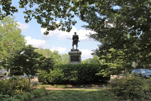
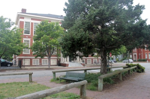
The prequel to this article covered three of Richmond’s pocket parks: Lombardy, Meadow and Harrison Park. Three more in the Fan are visited here, each with their own distinct character.

Sydney Park is one of the smallest pocket parks in the city but boasts one of the best locations. Situated at the five point intersection where Floyd bends at North Morris, Sydney serves as a backyard to the popular Crossroads Café. While it contains little more than a couple of benches and trees, it exists as a perfect pocket park – beautifying an awkward spot of roads and giving a place to relax for passing pedestrians.

A spot centered more towards children’s recreation is Paradise Park, designed in 1974 by the prolific Williamsburg architect/artist Carlton Abbott. Nicknamed ‘Geometry Park’ for its simply shaped playground equipment playground equipment, the site is bounded by two alleys in the block between Floyd and Grove, Vine and Allen. The winding brick planters enclose a mostly hardscaped area, with many seats but little greenery.

Perhaps the most well known and liked of these pocket parks in the city, Scuffletown was founded the same year as Paradise, the two parks intended as sisters, and revitalized through volunteer efforts in 1999. Its lot, located between Stuart and Park, Strawberry and Stafford, boasts possibly the densest, widest variety, and most polished plantings of any pocket park in Richmond. Two small gardens are split by a brick walkway that connects seating areas at each end of the park. Its long history includes being the site of a local tavern and legend of a Revolutionary War “scuffle.”

For the next installment of the Pocket Parks series we will move outside the Fan, so be sure to check back.

M.F.A

Capitol Square


1780, original layout by Thomas Jefferson and Directors of Public Works
1816, first landscaping plan by Maximilian Godefroy.
1850-1860, second landscaping plan by John Notman

Bounded by Ninth, Bank, Governor and Capitol streets (the latter two now closed to vehicular traffic) 

A prominent Broadway producer and native Virginian, the late Richmond Crinkley once said that no trip to his home state was complete without a visit to Capitol Square. This was the epicenter of Virginia, he believed, the place where he regained his bearings. It is an oasis-like park amid a built-up American downtown city, a place with an array of fascinating landmark buildings, and a place populated with a range of public statuary ranging from the founding fathers to the father of the “massive resistance” movement to civil rights, U.S. Sen. Harry F. Byrd. Still another monument pays homage to those Virginians who worked to achieve some semblance of civil rights in a state—and city—that was the capital of the Confederacy. But officially, Capitol Square is the seat of the Virginia legislature and the official residence of its governor.

The Commonwealth of Virginia in 1779 relocated its government from Williamsburg to Richmond and expanded the town of Richmond westward from Shockoe Bottom. Six blocks at the top of Shockoe Hill were set aside for the government center. Thomas Jefferson, governor at the time of the move, envisioned the hilltop as the podium for a classical temple-like structure. He found his model in the Maison Carree, a Roman temple in Nimes, France during his stay in Europe as Minister to France. Sending plans from Europe, construction began in 1785 and the building was occupied in 1788.

In 1906 the Capitol was considerably transformed by the addition of two architecturally-compatible wings to hold the House of Delegates and the Senate. These were designed by Peebles and Ferguson, a prominent Norfolk firm. In a reaction to security concerns following the 2001 attacks on the World Trade Center, Virginia leaders, like others nationwide were highly concerned with the security of public places. This thinking drove an underground addition on the southern side of the building and the development of a new public entrance off of Bank Street. The Hillier Firm of Philadelphia was architect of the expansion.

The Executive Mansion, completed in 1813 and built from plans by noted Boston architect Alexander Parris, is a neo-classical building inspired by the works of Robert Adam, a British architect, and fellow Bostonian Charles Bulfinch. The restrained exterior includes a front façade with five bays and a delicate, temple-front single story portico. The building was expanded in 1908 on the rear with the addition of a large dining room. A more recent renovation expanded the dimensions slightly by adding a modest service area. It is the nation’s oldest governor’s residence in continuous use.

Other interesting buildings in the square include the Bell Tower (1818), a severe neo-classical structure that is at the southwest corner and on axis with Franklin Street. The Oliver Hill Building (1913), on the eastern side of Capitol Square, is a Colonial Revival structure that once housed the Library of Virginia and now serves office functions.

The most imposing statue in the square is the equestrian George Washington monument (1858) sculpted by Thomas Crawford. He is surrounded by depictions of other Virginia patriots– Thomas Jefferson, Andrew Lewis, James Madison, John Marshall and Thomas Nelson. The statue was designed as the final resting place of the great general though he remains at Mount Vernon.

While there is limited vehicular access to grounds, the limitless pleasures of the pristine Capitol Square deserve to be enjoyed on foot.

E.S.

Pocket Parks: Part I


A pocket park can be defined as a small landscaped space that provides a sitting or recreation area, usually constructed on a vacant or underutilized lot. Pocket parks, while little and often hidden, can increase surrounding home ownership values, fill in an irregular plot of infrastructure convergence, and provide a convenient solution to finding usable open space in a dense urban area. Richmond has more than its fair share of these pocket parks; this article will cover three of them.

Two of the most well known pocket parks, Lombardy Park and Meadow Park share commonalities both in geographic location and the circumstances of their settings: both are triangle shaped and ease the convergence of two popular Fan roads. Meadow Park brings together Stuart and Park Ave, and a few blocks to the east, Lombardy Park splits Hanover and Park. In both these situations a pocket park is perfect infill and gives the surrounding houses a better view than simply a wide street.

Lombardy Park is surrounded by a short brick wall and small cast iron gates, shrouded on nearly all sides by mature trees. It contains seating areas, a sand box and playground, and houses a fall festival annually.

Meadow Park, on the other hand, is wrapped by a brick sidewalk, and protected mainly by bushes. Roughly the same size as Lombardy, Meadow contains no playground, more sitting areas and a fountain, but most memorably a seven foot tall bronze statue at the eastern tip of the triangle, a monument to the first regiment of the Virginia Infantry.

Harrison Park, the third pocket park on the aptly named Park Avenue, exhibits a more urban presence than Lombardy or Meadow, while similar in many ways to the other two. This is due in part to its smaller scale and sparser plantings, with its sides unencumbered by bushes or waist-high walls lending to easier access. The triangle functions more as a small city plaza or square as opposed to a park, with VCU students spilling out from the surrounding campus and closely spaced streetlights slowing traffic on Harrison Avenue. And unlike Lombardy or Meadow Parks, Harrison Park leads to the ending of two streets, making the space a more natural destination for pedestrians rather than a widened median.

Check back later for coverage of Richmond’s pocket parks, and let us know if you’ve found one we haven’t!

Current: Hargreaves Plan for River Development

In mid 2011, the Cambridge office of the internationally renowned firm Hargreaves Associates was awarded a $490,000 commission from the city for a (re)development of Richmond’s Riverfront. The firm has already undertaken successful riverfront plans for cities including San Francisco, Louisville, Houston and others. This month, the final draft of the Riverfront Plan was unveiled.

The target area includes the portion of the river from the Robert E Lee Bridge to the Henrico County line and Ancarrow’s Landing. Intending to build off the framework of the 2009 Downtown Master Plan, the plan focuses on accessibility and recreational uses. The plan is ambitious, calling for a wide range of improvements, including more public art, bike paths, completion of the capital trail, rowing clubs, revamping of watercraft sports, and cultural venues. Accessibility is also a common point of the proposal, through developing new pedestrian bridges and various completions of old trails to Belle Isle, Browns Island and Mayo Island. Other designated areas of focus are Chapel Island, Manchester, Tobacco Row, Ancarrow’s Landing, and the Tredegar Green. A prevailing technique used in many locations along the river are terraces, easing the level of descent from recreation to the water’s edge. The proposals are comprehensive, covering ecology, land acquisition, possible roadway change and future urban development.

Despite the wide aims of the plan, Hargreaves emphasizes that it will function as “a single, unified, cohesive system,” and that benefits from subsequent riverfront investment will spread to other neighborhoods of the city. To break up the magnitude of Hargreaves’ vision, the plan is divided into three priorities. The first, headlined by improvements to Mayo Island and Brown’s Island, is estimated at 35.4 million dollars.

Mayor Dwight Jones acknowledged that “The Richmond Region exists because of the critical role the James River played in our history” and acknowledged the importance of this plan with a $5 million addition to the Capital budget in 2013 and 2014.

Unlike countless past riverfront development strategies gone unrealized, the energy brought about by Hargreaves’ plan will hopefully lead to implementation. Before releasing the final plan, the firm completed a series of three popularly attended town meetings to discuss and edit their strategies. You can find all of their presentations online here:


http://www.richmondgov.com/PlanningAndDevelopmentReview/PlansAndDocuments.aspx

M.F.A.
Photos courtesy of Hargreaves Associates.

Forest Hill Park

Date: 1933 (purchased by City)
Address: Main entrances at Forest Hill Ave and West 41st St; New Kent Ave and West 42nd St

Forest Hill Park has a surprisingly large footprint, and when one has walked the meandering cobblestone paths through wetlands to the central lake, it is easy to feel completely secluded from the urban environment. This sensation in the heavily wooded valley is reinforced by the presence of river otters, great blue herons, and other creatures unusual in an urban climate, a condition brought about by the amount of storm sediment in the park.

The rocky, wilderness-like 105 acres link the important Southside intersection of Forest Hills Ave and Semmes Ave to the south, and a section of the James River park system to the north. Historically, its location served as a catalyst of development for Forest Hill, Woodland Heights, and Westover Hills neighborhoods. However the park existed as private property for many generations, passing first through the hands of William Byrd III, son to the founder of Richmond. Holden Rhodes purchased the land in 1820, and built an estate there that still stands today.

In 1889, the land was sold to Southside Land and Improvement Co., who used the land as an end stop for the Forest Hill trolley route. During this time the additions to the Rhodes House included a carousel, roller coaster, golf course, swimming area and other amusement park attractions in an effort to lure passengers to the trolley terminus. The Great Depression caused the station and the amusement park to close, and the City took over ownership of the land, turning the area back to its natural state and the Rhodes House into a library and meeting house. The park received improvements from the Works Progress Administration, including construction of the stone gazebo along the lake and plants that would later become the Azalea Garden in Bryan Park. For this and the Rhodes House, Forest Hill Park was placed on the National Register of historic places in 2002.

Some of the main attractions to the park today include a popular sledding spot, as well as the South of the James Market, which brings hundreds of shoppers to the park every Saturday in the summer and fall for an open air locally sourced market. Friends of Forest Hill Park is an organization dedicated to the well being of the park, and since 2009 has been developing a comprehensive plan for its future, including supporting native species and protecting the valuable water resources.

M.F.A